Independence to Bishop

61 miles – 6/9/18 – 6/13/18

While in Independence, which was not much of a town at all, I the bus back to Lone Pine to resupply and revisit some of my “old stomping grounds” since I spent so much time there. Since the bus only ran three times a day and resupplying doesn’t take that long, I stopped by the Frosty Chalet for a milkshake before trying to hitch hike back to Independence. On my way I noticed a large group of hikers trying to hitch hike and figured that it would probably take me a while to get a ride as they would intercept any rides. However, it turns out that people who give rides also like milkshakes. Right as I started to hitch a couple that I saw inside the Frosty Chalet pulled out and offered a ride. Turns out that they were a couple from Tennessee that were road tripping across the united states, hiking and climbing along the way.

Before heading back to the trial I had some amazing french toast for breakfast in a make shift restaurant inside a co-op which was only open a few days a week . I then hitchhiked back to the trail that would take me back to the PCT, I ended up getting a ride from a really friendly guy that shared a lot of history about the area.

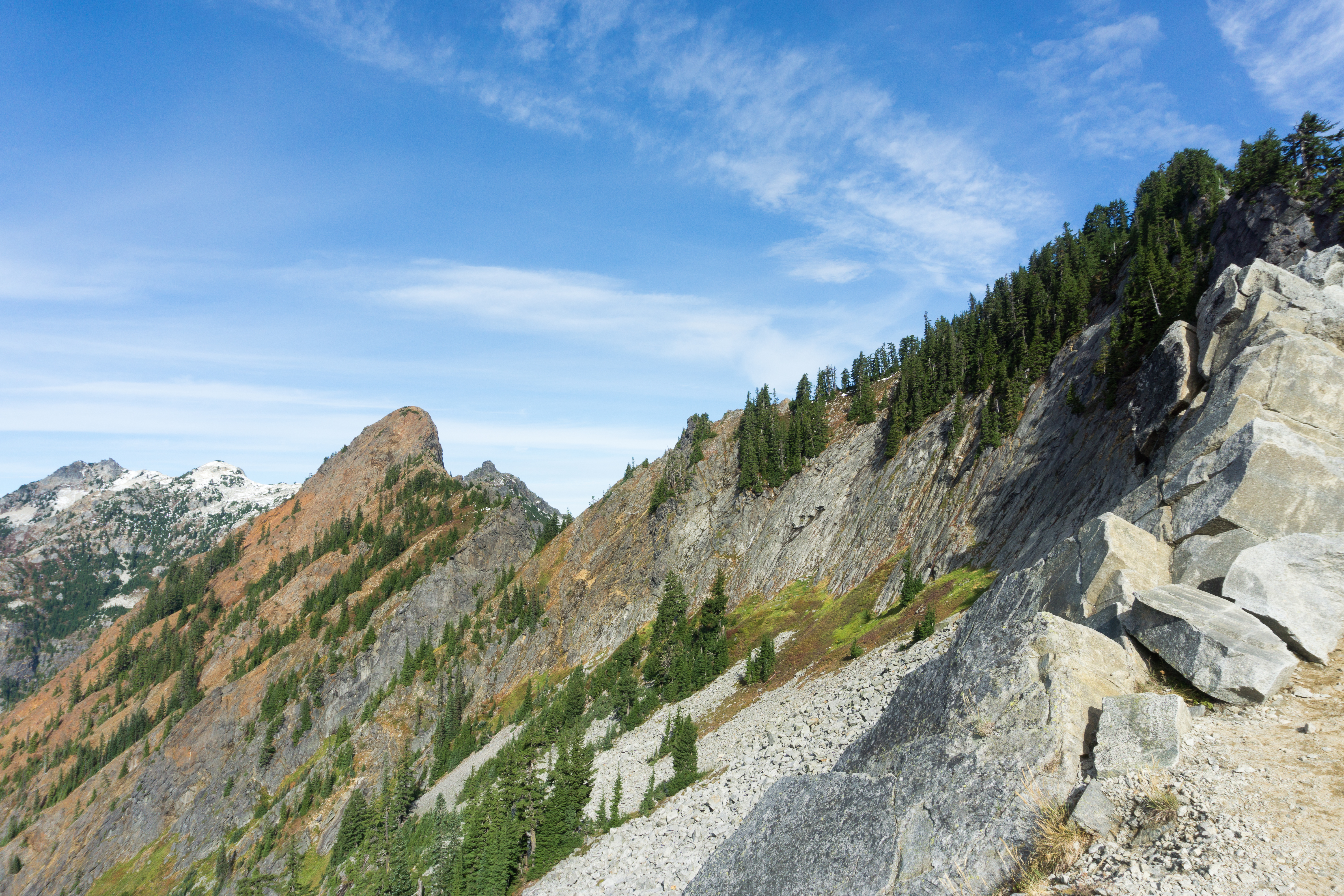
The climb back up Kearsarge Pass was easier than expected, it seemed like it was gong to be hard going as I was coming down a few days earlier. Once I got to the top it got a bit windy, so windy that it my hat got blown off my head and carried over the peak. I spent a good 10 minutes looking for it trying not to side down towards the lake below. I eventually found it around the other side. I hiked a bit further to the junction with the PCT and set up camp for the night ready to go over Glen Pass in the morning.

The hike up Glen pass was fairly easy, just the random bits of snow to deal with along the way as the trail passed a few small lakes.

However, coming down the other side was a bit challenging. While I could tell where the trail was the switchbacks were buried in snow. Instead, the easiest path down followed a ridge of exposed rock, which wasn’t too difficult to move through except the parts that really icy with frozen melt water. I slipped and fell on my ass twice, luckily my backpack helped break my fall.

As I continued down a found a great stretch of snow to glissade down. I was exited to slide down the snow like a penguin, except on my butt instead of my belly. I was so exited in fact I forgot that I needed to use my ice axe to control my speed. I ended up going too fast and having to bail out with only my hands to stop me. which ended up getting scrapped up.

Once I cleared the snow I made it to Rae Lakes, which were really beautiful. At one point I was greeted by a surprise water crossing where one lake drained into another.

As I continued on I had a couple more water crossings. Luckily one river had a suspension bridge over it. The bridge itself was limited to one person crossing at the time and swayed about when crossed. After crossing the bridge I started to climb back up and continued up a couple miles, past the 800 mile marker, to get a jump on Pinchot Pass.

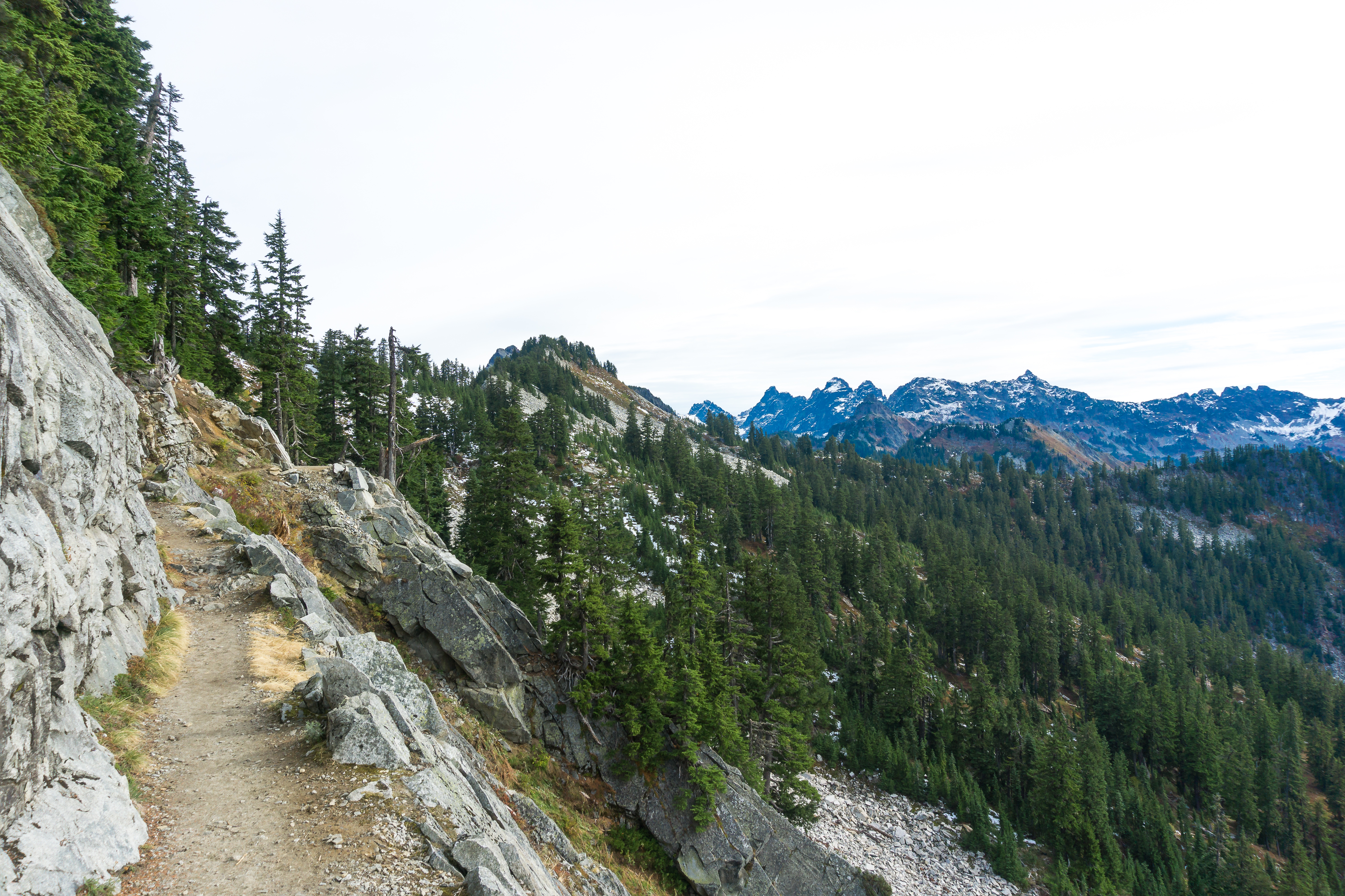
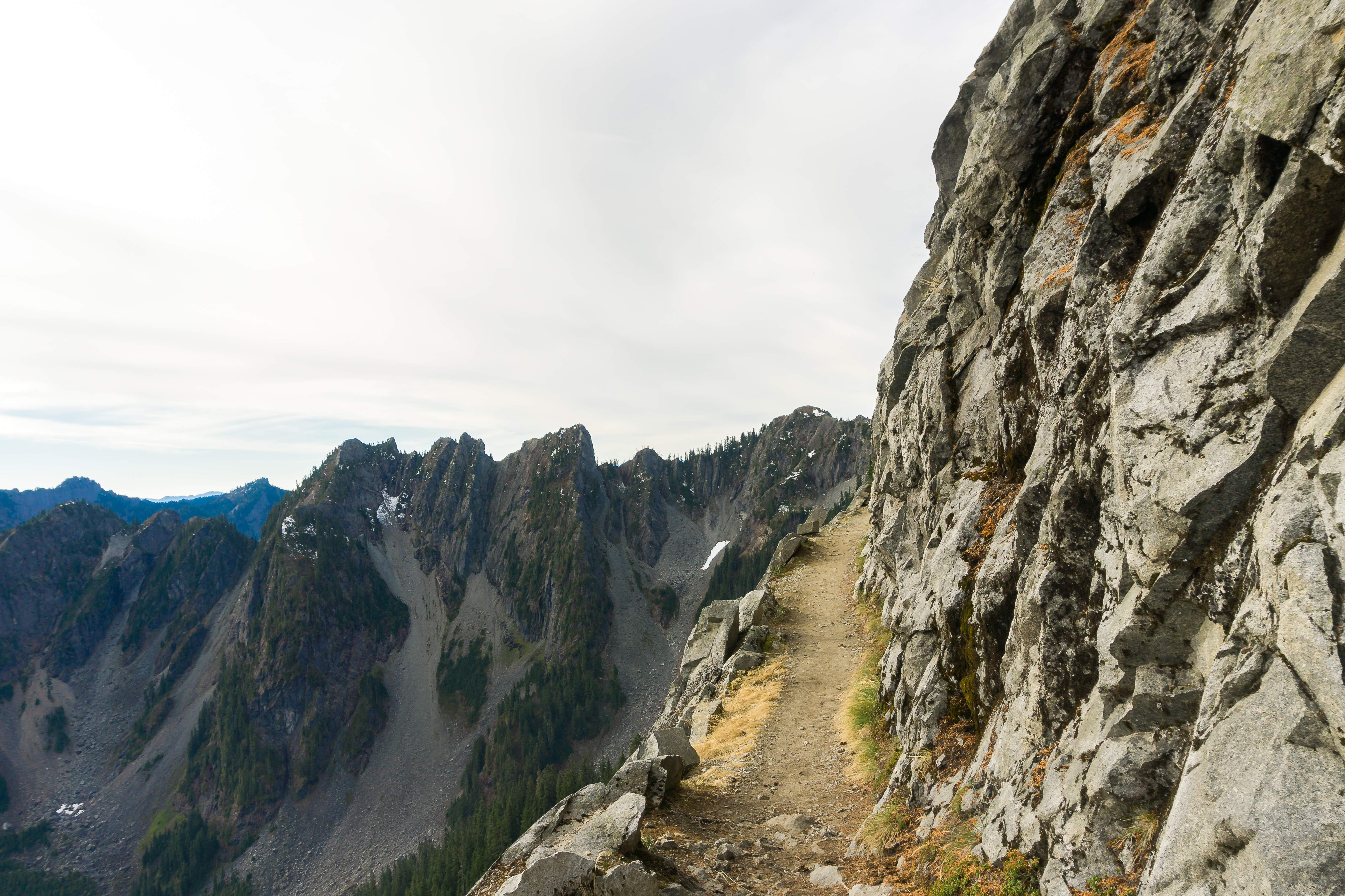
In hindsight I wish I would have gotten a bit closer to Pinchot Pass the day before. While the climb up to the pass started as expected it became hard to follow as I hit the snow fields . The path in the snow field would go in what seemed like the right direction but you would then spot an exposed portion of the trail further up or down from where you were, which made for some annoying transitions between the two.

Once at the top descent was easy with micro-spikes. There were random patches of snow as the trail passed a handful of lakes.

As the trail continued down it crossed a couple large creeks and a full on river at the bottom. The river was the trickiest water crossing yet but I obviously made it across.

I climbed up a few more miles and crossed a few more streams before setting up camp a couple miles from Mather Pass (are you seeing a pattern here?), which has a reputation of being somewhat terrifying because of its large head wall. As I was in my tent trying to fall asleep I saw a helicopter come in from the west. It flew up into the mountains and then back down, circling before dropping down out of sight. It seemed to be back by there river I crossed earlier in the day. Suddenly the possibility of serious injury came to the front of my mind and the thought of Mather Pass made my anxiety kick in.

Luckily Mather Pass was nothing to be afraid off, it was mostly snow free and while the switchbacks were tight I at no point felt a fear of heights. The way down was a bit tricky as it was still pretty snow covered, following one set of boot prints in the snow would lead to a melted out section where I had to scramble down.

As the trail cleared it winded down next down to some lakes and a creek that would eventually join to become the middle fork of the king river. All was well until I hit a series of switchbacks which seemed like they would never end. After getting to the bottom of the switch backs there were a number of interesting water crossings due to snow melt. I hit the low point before starting the climb back up towards the next pass. However, instead of continuing on I would be taking Bishop pass out to the city of Bishop where I would take a bus to Reno to meet up with Cristina. I continued on to the ranger station (which wasn’t manned) at the junction with Bishop Pass. I thought about calling it a day but decided to push up the pass a couple miles to get a jump on the following day as Bishop Pass was a little more substantial than the previous bail out points.

In the morning I was greeted by an immediate water crossing, nothing like wet feet as you get ready to hike in the snow. The steep switchbacks gave way to an amazing alpine area with small ponds before hitting more snow on the way to the top of the pass.

The drop down from the top was manageable with a few scrambles due to snow cover and the hike out had some breathtaking views and stunning lakes. The closer I got to the trailhead the more day hikers I saw. Shortly after arriving at the parking lot I was able to catch a ride down into Bishop which was extremely hot, at least to me.

A few days later, after sampling the restaurants in Bishop, I hopped on the bus to Reno where I’d meet up with Cristina. However, I also had to say to my hiking partner Sisse, her visa was up and she had to return to Denmark. The following day Cristina arrived and we enjoyed a couple days at the Peppermill Casino which included a much needed spa day and a massage.

Lone Pine to Independence

45 Miles – 6/2/18 – 6/6/18

It’s easy to end up spending a few days in Lone Pine, which is exactly what I did. Plenty of places to eat including a couple amazing taco trucks., When I tried to hitch back to the trailhead I didn’t have much luck so I took a break and had a beer. After a beer or two I decided that it would probably be easier to hitch out in the morning so I stayed another night and ate more tacos.

The next morning I was able to catch a ride back to the trailhead by a couple from LA doing an overnight trip. In the Sierra. Once I got back to the PCT I hiked up to Chicken Lake where I stopped for lunch before continuing a few more miles before camping for the night.

In the morning I hiked up to the Crabtree ranger station and set up camp in the early afternoon. I had heard of hikers camping a little closer to Mt. Whitney at Guitar Lake but my understanding is that the ranger station was as close as I could get with just my PCT permit. I’m sure I could have camped at Guitar lake and been OK but the ranger station also had a pit toilet, which is a rare find on the trail. The idea was to take it easy and rest before hiking up Mt. Whitney the following morning. However, my tent turns into an oven in direct sunlight so I wasn’t able to get much rest before the sun calmed down. I did get to hang out on porch of the ranger station, which was nice.

When my alarm went off at 2am I only grabbed the things I would need to get up Mt. Whitney, ate a quick breakfast and headed out. It was nice being able to leave my tent set up and carry a lighter pack since I would be returning to the ranger station. Hiking in the dark was a little annoying but it was fun to see other hikers headlamps on the side of the mountain as they headed up the trail.

I crossed a few small snow fields on my way to the switch backs up the mountain. Once on the switch backs there were random patches of snow and ice but nothing too tricky. After reaching the junction summit the snow became a little more prevalent but still nothing too challenging. The sun started to rise and lit up the mountains as I made my way up to the summit around 6am. I was a bit intimidated by Mt. Whitney, the highest peak in the contiguous united states, but it ended up being easier than I had feared. There were a handful of other hikers at the summit enjoying the view, I stayed for a little while and had a snack before starting to head back down. I’m always cautious of snow getting too soft and making the descent tricky.

On my way down there were a good amount of people heading up, which was a little surprising. As I headed back to the ranger station I was able to see all the scenery I passed in the dark which made it feel completely new.

I got back to camp around 11am and tried to spend as much time as I could in my tent before it turned into a sauna again. Once it cooled down I quickly fell asleep and even slept in a bit in the morning.

In the morning I packed up and hiked a mere 9 miles to the base of Forrester Pass, the highest point on the actual PCT. On the way I went over Bighorn Plateau and crossed a couple large streams which required getting my feet wet. Once across the last water crossing I set up camp, making sure that my tent had plenty of shade.

I once again woke up early, luckily not at 2am, and headed up to the pass. I wasn’t quite sure what to expect but I was prepared for a hard climb. The first few miles were nothing crazy, just a few snowy bits. However, once I got to the bottom of the final push up to the pass there was a good amount of snow making it tricky to find the trail. Luckily it was still frozen making it easy to hike on. Since it was difficult to spot the trail I scrambled between patches of snow and rocks until I made my way to the switchbacks which were snow free, with the exception of the chute right before the top of the pass.

Once at the top I was able to see down into Kings Canyon National Park, which was stunning, even with all the snow I’d have to deal with. Surprisingly getting down wasn’t too bad, there were plenty of footprints that made great steps and we’re easy to follow.

When I got further down into the canyon I was awestruck. It felt like I finally entered the Sierra, even though I already technically had days ago. I hiked along a large “creek” and the trail was pretty tame.

Knowing that I’d be heading out to Independence the following day I decided to push a little more and get into town a day early. There were a few water crossings and another climb up to Kearsarge Pass, which was luckily snow free.

The trail to the pass was beautiful, passing by a few lakes. The climb over the pass wasn’t technically that difficult but after going over Forrester in the morning it felt like it. Once at the top of the pass I was able to get a sliver of service and called a motel that was able to pick me up from the trailhead. Somehow the guy pulled up just as I was getting to the trailhead and I rode back down into the hot desert. I checked into the motel, took a shower and got some sleep.

Tehachapi to Kennedy Meadows

135 miles – 5/17/18 – 5/25/18

In my last post I forgot to mention that I was given a trail name, two actually. The first one was “Bloodhound” because I can always find great spots for a break or to set up camp. I tried it out for a couple days but it didn’t feel right. I was then given “Strider” because apparently I can just stride up climbs with my long legs

I spent my time in Tehachapi the same way I do whenever I stay in a town, eating and being lazy. I’ll usually get sucked in to binge watching some reality TV show like Catfish or Naked and Afraid. However the hotel I stayed at had a hot tub and a pool, so that got added into the mix. My favorite place I ate in Tehachapi was Red House BBQ, some of the best BBQ I’ve had in a long time. The town itself was pretty spread out so I got a few rides from the one Uber driver and when she wasn’t around called the taxi company which only seemed to have one car. I was able to tell because one of the mirrors was broken off.

Before heading back to the trail I grabbed some of the breakfast at the hotel, stealing a bunch of hot sauce packets and jelly. The same Uber driver showed up to give me a ride back to the trail where I ran into someone I hadn’t seen in weeks, the creepy guy from the start of my hike. He didn’t exactly remember me and was heading into town which was a relief.

I started down the trail which ran along the highway. A guy that was pulled over on the side of the highway asked me if I needed anything, stated that he had everything I could want, I settled on a Dr Pepper. He told me that he just quit his job and was going on a road trip before finding somewhere to start new.

Loaded up on sugar I followed the trail back into the hills. After reaching the top things became a little more wooded. It didn’t get as warm as I had hoped so when I found a place to camp I crawled right into my sleeping bag and ate dinner.

The following morning I actually slept in! All the way to 7:30am, which is an hour and a half later than usual. After eating breakfast I made the short hike to a spring to fill up a gallon of water. Generally I shoot for a liter for every 5 miles and I was going 20 with no other water sources on the way.

I started out hiking through pretty exposed areas and after a couple good climbs, passing the 600 mile marker, ended up in a forest. I found a spot to camp at another spring.

From the spring the trail winded through a nice wooded area before dropping down to a campground full of people riding dirt bikes and shooting guns. I used the bathroom (always a welcome amenity) and filled up my water. The climb out of the campground went through a burnt but rocky section. At the top there was a great view of the mountains ahead before beginning the desent back down to the desert.

At the bottom I came across a giant water cache, easily over 100 gallons, which was a welcome sight as the next water source was still a few miles ahead with a 2 mile detour. The climb after the water cache wasn’t too drastic on paper but the heat and sandy trail made it less than fun. When I hit 20 miles for the day I was ready to set up camp but as much as I wanted to I was unable to find a good enough spot. I pushed on for a couple more miles and found a nice spot under a joshua tree.

In the morning it was just a handful of miles to the next giant water cache. However, I once again found myself climbing up a sandy trail. Once I arrived at the junction with the water cache I was very excited to see a group of people hanging out under a tent. It was some trail magic! A couple of trail angels were set up with all kinds of stuff they were very eager to have consumed, so I helped. I had a Coke, a Gatorade, a Dr. Pepper, carrots and celery, Pringles and a couple of granola bars. I was now more than ready to power up the next hill, which I did easily.

At the top I stopped for a nice long lunch before heading down the back of the hill. On my way I ran into the trail angles from earlier hiking up! They said there was a surprise at the bottom. I headed down the switchbacks and at the bottom I spotted one of their coolers filled with soda! I drank another Coke and a root beer.

The next bit of the trail was wooded and a bit grassy before joining with a very worn dirt road, which was not very fun to walk on. I followed the crappy dirt road to a campsite with a somewhat creepy cabin. For the first time in a while I decided to set up my tent instead of cowboy camping and settled in for the night.

After a few miles of morning hiking, with a few great views, I arrived at Walker Pass ready to hitch into Lake Isabella for the day. However, this proved to be more difficult than I expected. After about 30 minutes of unsuccessful hitchhiking some more hikers showed up trying to get a ride as well. One guy took a ride to a town in the opposite direction. There were no Uber or Lyft drivers to be found, I imagine one could make a killing from hikers alone. I started to consider trying to get a ride to the town in the opposite direction a van showed up to drop off a couple hikers.

The van was covered with all sorts of paint and the hashtag #greatfuldad. The driver was a deadhead that was giving rides while he waited to meet up with his daughter who was hiking the trail. He busted out some paint and markers and told everyone to sign his van, which we did. Afterwards we all pilled in and made the 30 minute drive to Lake Isabella.

I checked into a very basic and outdated motel which I wouldn’t stay in if I wasn’t spending most of my nights outside. The owner was friendly and even kept a hiker box full of random things. Lake Isabella itself, while it had a few good spots, seemed like a notable portion of the population were on meth. Despite this, I decided to spend a second night there as based on what I heard from others the conditions in the Sierras was still causing hikers to bail out and planning on taking a week off before planning on attempting to go back in. I figured another day of rest, and another day for conditions to improve, would be a good idea.

When I finally left Lake Isabella it was early. After waking up at 4:15am I walked a mile to catch the 5:20am bus back to the trail. The bus only ran 3 days a week, three times a day. Not surprisingly the only riders were sleepy hikers. Once back at the trail I climbed back up, this time into mountians. At one point I could look back down into the desert hoping it would be the last time I would see it.

The trail continued it’s trend of climbing up and then dropping back down a couple times before I reached a campsite at the top of one of the climbs. Being in an area with more peaks than hills made me happy and excited to get into the Sierras.

The next day followed the same pattern of ascending and descending before a long winding drop into a valley. I spent the night next to a trickling stream where a bear had been a problem last year. I guess the bear decided to move on because there was no sign of one.

The next morning I hiked the last 10 breathtaking miles into Kennedy Meadows. I’ll be taking a day off here, I can only make it so far north because of snow so I’ll be taking it slow until I meet up with Cristina in Reno. Since I won’t be able to hike that far north I’ll have to bail out of the Sierra and take a bus into Reno.

Working The Kinks Out

Most of the hikes I’m used to range anywhere between 6 and 12 miles with a decent amount of elevation gain. However, on the Pacific Crest Trail I will being over 20 in a day once I hit my stride.  When you cover that much distance, day after day, you’ll start to notice things you wouldn’t after a day hike or weekend backpacking trip. That slight poke in you’re used to ignoring will  back will eventually feel like you’re being stabbed, that odd spot in your hiking shoe will make your feet scream. Even your clothes can become an issue, the chaffing struggle is real.

To try to get ahead of these things as much as I can I’ve been throwing all my PCT gear in my backpack and racking up some serious miles, trying to identify the pain points and adjust accordingly. My go-to spot is the Iron Horse Trail just outside North Bend, WA.  Not only is it close by but it’s long, flat and has some nice views.  Since it’s flat I can keep my pace up and really get some serious miles in.

The long flat hikes also allow me to calculate my base pace, which is currently around 3.5 miles an hour. 8 hours of hiking would put me at around 26 miles, 26 flat miles. Since the PCT is far from flat i’ll be using my base pace along with the elevation gain to calculate the distance I plan to cover each day.

During my first hike on the Iron Horse I covered 14 miles without stopping and discovered a few problem areas with my pack which came very apparent near the end. My backpack was unbalanced and the edge of my sleeping pad was poking me in the back.  I made adjustments and returned, covering 17 miles without issue, other than being a little sore, I don’t know if  I’ve ever gone 17 miles without stopping before.  I was feeling good about where I was at and decided that I was ready to add some elevation into the mix. It was also nice to practice things like snacking and drinking as I hiked as well as charging my phone and taking photos along the way.

Before taking off on my next hike I took some time to really look at what I was carrying in my backpack. To do this I turned to Lighterpack.com to track everything. I broke out a scale and weighed everything, logging and categorizing each item. I wasn’t too happy with where my base weight ended up and slimmed down what I was carrying.  The sleeping clothes I was bringing weighed over 1lb, I decided that my sleeping bag liner would keep my sleeping bag just as clean at a fraction of the weight. I didn’t need the small shovel or an extra flashlight.  I cut down what I was bringing to exactly what I needed.  Here is how everything weighed out (Click here to see a detailed list of what makes up my base weight). I’ll  continue to refine what i’ll be carrying with me and update the list as I go.

With my base weight  at 15 lbs and 3.5 ounces, with room to improve, I was feeling pretty good about where things were.  Per the 2017 PCT Thru Hiker Survey at Halfway Anywhere the average base weight hikers started with last year was 19.49 lbs and the average base weight they finished with was 16.51 lbs.  If you’re a data nerd or just want to understand more the PCT hikers last year, take a closer look at the 2017 PCT Survey, there is some really interesting information, at least I think so.

With my backpack and base weight dialed in I ventured to one of my favorite spots, Squak Mountain.  With a diverse network of trails it’s easy to hike as much as you want with plenty of challenging bits if you know where to go.  In 3 hours I covered 9.24 miles with a decent amount of elevation gain and loss. Unfortunately my fit bit didn’t seem to want to track elevation that day.  However, my pace only decreased slightly with the added elevation.  Next time i’ll use my actual GPS, which I still need to figure out.

From here on out i’ll be getting out and hiking with all my gear every chance I get, starting to practice setting up everything and packing it all up again as well. The more I figure out before I hit the PCT the better, hiking the trail itself will be enough of a challenge.

Kendall Katwalk

What’s the best way to prepare for hiking the Pacific Crest Trail? By actually hiking on the Pacific Crest Trail of course. A few weeks ago I set out to do just that by revisiting one of my favorite hikes from last year,  the same hike which made me decide to hike the entire PCT, Kendall Katwalk.

I woke up early and made the drive up I-90 to the PCT trailhead at Snoqualmie Pass. As I pulled into the trailhead the fact that I will be spending 5 months, give or take, on this very trail  really started to really sink in. I felt a mix of excitement and anxiety as my mind was flooded with thoughts of  how amazing and challenging the journey will be. Not to mention all the things I had left to do to get ready. However, once I threw on my backpack and started down the trail the anxiety quickly subsided leaving nothing but excitement.

The trail starts off wooded with glimpses of the surrounding mountains through the trees. The trail itself is nice and smooth with a couple of small streams to cross before opening up into talus. Hiking on rocks is not my favorite but the views more than made up for it.

You make your way back into the tress as you continue up, crossing a few more streams before hitting a clearing which offers a view of the ridge above. In some spots you have to work your way through the abundant foliage.

You will hit a few switch backs and will continue to be provided with fantastic views of the Alpine Lakes Wilderness area.

Continuing on the trail you will be greeted by some prominent peaks straight ahead of you letting you know that you’re getting close to the ridge. After turning a corner you begin the final push to the katwalk. A you get closer your can start to see valleys on both sides of you.

Once you make your way to your way to the katwalk it becomes clear that you are at the top of the ridge.  Turn left and your looking down into one valley, turn right and you’re looking down into the other.

The katwalk itself is a narrow path blasted out of the side of a cliff, a few hundred yards long.  When I arrived I was the only one around so I took the opportunity to take it all in.

As you make your way along the katwalk you have a spectacular view of the mountains to the east…

… and the valley below.  If you look close enough you can see Silver Creek at the bottom.


Heading back I began to wonder what it will feel like when I hit this section of the PCT next year. Realizing that at that point I will have hiked over 2,000 miles and had taken a day or two to visit family and friends I haven’t seen in months,  only to get back on the trail and continue on to Manning Park in Canada, with some tough hiking ahead in the North Cascades. Luckily being so close to Seattle I’m sure I’ll have a few people join up with me for parts of the final push.

Bring Your Own Llama

Annette Lake will always hold a special place in my heart and not just because the sign at the trailhead promotes the fact that llamas are allowed on the trail, although that is one of the many reasons.  

When I first rediscovered hiking a few years ago Annette lake was one of the first hikes on my list. I recall convincing my friend Derek to join me on my first trip. We started up the trail in the afternoon not really knowing what to expect,  moving slowly and trying to figure out how far was had left ahead of us.  We didn’t have maps or cell reception but tried to make educated guesses based on the elevation data from the GPS on our phones. Not only were we lacking in navigational resources but many other essentials as well, as would become very apparent.  As we continued on the trail we began to hear thunder in the distance which not only became closer and louder,  but from multiple directions.  Luckily we were smart enough,  or more likely tired enough,  to decide to turn around.  The thunder continued to intensify until the sky opened up and poured down rain. Not wanting to get struck by lightning we began to run down the trail, trying not to slip and fall. After coming close to rolling my ankle a few times,  maybe falling once, and getting soaked to the bone we ended up back at the car and drove home.  I’d later find out that my camera, a decent DSLR, somehow got damaged to the point that it wouldn’t turn on and I had to buy a new one. 
Despite a challenging first attempt I was determined to make it to the lake. After getting a few more hikes under my belt, and making sure I had proper rain gear,  I cautiously returned to finish the hike.  As soon as I started down the trail I was surprised by a very unexpected text message from a friend,  and avid hiker, that I hadn’t heard from in a long time.  I took it as a sign that I picked the right day to come back. The hike and the lake was stunning and it felt great to finally make it all the way. 

Since then I have returned a few times,  sometimes as an introductory hike for friends. When I discovered that Cristina had never been it moved to the top of our list and in early July we crossed it off. 

Before heading up the main trail you can take a quick detour down a short trail to a nice little waterfall.  The trail itself is pretty gentle,  crossing under some power lines and across a forest road before hitting a series of switchbacks. 

As you continue on you’ll come across one of my favorite “bridges”, a couple platforms lead to the “bridge” which consists of steps cut into a large downed tree with a wooden hand rail. 

A little further up there is another smaller waterfall that cuts down through the trees.  

As you near the top you’ll pass across a couple avalanche chutes where the break in the trees reveals some nice views, which apparently I didn’t take any pictures of this time.  The trail flatens out as you approach the lake. 

The lake itself sits below some impressive peaks and just asks to be swam in.

Cristina and I made our way around the lake until we found a place to escape the heat, set up our hammocks and relax for a while. 

When we finally gave into the fact that we couldn’t stay forever we made our way back down and just like every other time I visited Annette lake I didn’t come across someone with a llama, maybe I need to become the guy with a llama. 

The Enchantments

The area known as “The Enchantments” near Leavenworth, Washington is one of the most popular hiking destinations in the Pacific Northwest. Due to it’s popularity a lottery for a limited number overnight permits is held early each spring, which I never seem to have lucky with.

In the lottery you specify the date you are hoping to start along with your desired zone, the most sought after being a “Core Permit”. Not only does a Core Permit allow you to camp in the Core Enchantment zone, which is what most people think of when you mention The Enchantments, it also allows you to also camp in any of the other zones as well.  After the Core Enchantment zone the most popular zone is the Colchuck followed by Snow and Stuart zone. The least desired zone in  The Enchantments is the Eightmile / Caroline Zone as it does not have a trail which allows you to access the  Core Enchantments.  After the lottery there always ends up being some Eightmile / Caroline permits available.

Even though the Eightmile / Caroline zone is the least popular zone in The Enchantments it is still a spectacular area to visit and since my lottery losing streak continued this year I picked up a permit for Cristina and I. We drove out to stay with friends in Plain, Washington, which is close to Leavenworth and The Enchantments. It is here were I tried to stuff all my gear into my backpack for the first time. After a few very frustrating hours full of swear words, I manged to get everything to fit. All Cristina ended had to carry was her own sleeping gear, toiletries and clothes, I was able to carry everything I would on the PCT. I was so happy when I got everything to fit I had to take a picture.

The next morning we headed out early to grab coffee and unsuccessfully attempted to get a better permit at the ranger station, we did however have a backup plan.  The plan was to knock out a hike up to Colchuck lake, which is the most popular day hike in The Enchantments, before hiking to Eightmile lake to spend the night.  After stopping for breakfast we drove up the surprising smooth forest road to the Stuart Lake trailhead and headed out.

The trail starts off pretty tame with minimal elevation gain, crossing a very aggressive creek about a mile and a half in. 

On our way up we passed a good amount of wildflowers as we darted in and out of the the tress, enjoying the shade they provided as it was starting to get rather warm. 

After hiking for a few miles we hit the junction with the trial up to Colchuck Lake, the main trial continuing on to Lake Stuart.

A short distance down the Colchuck Lake Trail we were again met by the angry creek and a very cool wooden bridge which leads into a small boulder field which was fun to navigate thorugh.

The trial then begins to climb with more intensity with plenty of switch backs. At one point the trail crosses across a small waterfall, we both somehow managed to keep our feet dry while crossing.

Continuing up the trail we made our way to a clearing allowing us to look back down the way we came with a stunning view of Mt. Stuart in the distance.

The trail dipped back into the tress for the final push to the lake, at one point the trail intersected with a stream which was a little tricky to navigate through. Once we arrived at the lake we were greeted by the massive Dragontail Peak and  the slightly smaller Colchuck Peak with Asgard Pass between the two, which we would have had to conquer if we had a snagged a Core permit. I think we were both a bit relived that we didn’t as watching people make their way up was a bit intimidating.


After I took a quick swim in the extremely cold lake we ate lunch and started to head back down where we came across a very hungry mountain goat who luckily had plenty to much on and was too busy eating to be concerned with us.

Once we made our way back down to the trailhead we hopped back in the car and made the quick trip over to the Eightmile trailhead to begin our hike up to Eightmile lake.

The sun was rather intense as we made our way up but I found myself distracted by the abundance of wildflowers and some tiny pine cones.

The trail to Eightmile lake is fairly flat which was a nice change of pace after the hike up to Colchuck. A few miles in we hit Little Eightmile Lake which is also the junction for Caroline Lake, which would be our destination the following day.

After a quick break we continued onward as the trail climbed a bit before we arrived at the lake. We found a site and just as I finished setting up the tent a group of very loud college girls decided to set up camp just feet from ours. We quickly packed up, grabbed our backpacks and made our way to another, much better, site right by the lake. Luckily my tent is extremely easy to set up and take down.

After getting everything set up again I took a quick swim in the lake, which was just as cold as Colchuck but it felt amazing after hiking in the sun all day. As we were having dinner one of the locals decided to come dine with us (yes, those are flowers in it’s mouth).

We were both pretty tired after a full day of hiking and after staying up late enough to see the stars decided to get some much needed rest.

The next morning we followed the trial around the lake, hopped over some trees and found another angry stream cutting through the forest.

After breakfast we packed everything up and made our way back down the trail to Little Eightmile Lake where we started up the trail to Caroline Lake.  While the trail didn’t seem very difficult on paper it did prove to be a challenging hike.

The trail starts out rather steep and provides very little shade, which was sorely missed as the sun was blazing as we made our way up.  We would take a break every time we came across a bit of shade.

I even resorted to hiding from the sun in the narrow shadow of a large dead tree and soaking my hat in water to keep cool.

As I looked back down towards Eightmile lake I tried to visualize myself swimming in the ice cold water, it didn’t help.

A little further up the trail we met a couple on their way down and chatted for a bit. The said that the lake was spectacular and warned us about a Coyote they saw up at Windy Pass. We were considering making the hike up to the pass  but decided to avoid it after that.

However, as we rounded a corner about a mile later we were met by a lone Coyote standing in the middle of the trail staring us down. Considering that Coyotes are pack animals I decided to skip the photo and clanked my hiking poles above my head until he decided to head off the trail and run down into the valley. We cautiously continued to the lake without seeing or hearing another.

We found that not only were there no loud college girls at the lake but in fact there was only one other couple on the other side of the lake.  We set up camp and I took a swim in the warmer but still cold Caroline lake.  We spent the rest of the day relaxing before we were forced into the tent due to an army of mosquitoes that occupied the lake.

The next morning I somehow managed to get up early enough to catch a bit of the sunrise.

After enjoying the lack of mosquitoes at the lake for a bit we packed up camp and started our hike back down to the trailhead. We both had one thing in mind as we struggled through the heat….

…..a sausage and beer at Munchen Haus in Leavenworth!  While we didn’t end up hiking through the “real enchantments”, which is probably for the best, we made the most of our time in a really amazing place. Hopefully we can snag a core permit after I finish the PCT next year.


In my head

When you talk to someone who has completed the Pacific Crest Trail they will often tell you that the challenge in hiking the trial is not only a physical one but also, and perhaps more so, a mental one. On my recent hikes I’ve pushed myself pretty hard, seeing how fast I can make it to the end and If I can make it without stopping. In doing so hikes have become easier physically but more difficult mentally as you don’t take the time to enjoy the hike itself.  This became very obvious on my hike up Mount Teneriffe, a 14 mile hike with 4,000 feet of gain, this past Sunday.

I hiked up Mount Teneriffe last summer and remember it being strenuous but nothing that made me hate life, while I knew I was in for a challenge I knew it was one I could accomplish. The trail starts out very easy, about 2 miles on the very flat Mount Teneriffe Road before spotting the sign directing you towards Teneriffe Falls (aka Kamikaze Falls). After the junction things start go get fun, the trail becomes pretty steep and rocky as you make your way up to the falls.  As I made my way up the trail I found myself not really taking in my surroundings and focused on making progress. I wasn’t feeling it, which I found strange, but I pushed on. I made my way to the switchbacks where you start to see the bottom of the falls, I stopped to take some pictures and spent time texting them to friends as I continued on. I finally reached the best view of the falls, snapped a picture and moved on without spending time there to take it all in.

I found the trail that continues up from the falls to the summit of Mount Teneriffe, which is so steep you find yourself using your hands to help you make your way up. This is the part I knew would be challenging.  I pushed on until I made it up to the ridge and took a quick look around, finding myself in a cloud with no views. Onward I went, remembering all the challenging bits as I came across them.  The trail becomes faint as you make your way through the trees along the ridge.  I found myself becoming annoyed as I had to maneuver over a large boulder or up a steep part in the trail, but I continued to push on.  That feeling of annoyance became more prevalent as I hit the snow. I knew there would be snow I was just hoping it would be isolated to the summit. I had trekking poles and microspikes but couldn’t be bothered to get them out, luckily my new pair of Saucony Peregrine 7‎’s have some awesome traction and I slowly made my way through the snow. The snow became more prevalent the further I ascended and the trail became more faint. Then it started snowing.

As I continued up I started thinking about turning back, not because of the physical challenge or being cold, I was actually pretty comfortable, but because I just didn’t feel like hiking anymore.  I started to rationalize turning back, thinking about how I hadn’t seen a single person since the falls and concerned that I might lose track of the trail if it continued to snow.  I knew I was getting close to the summit and should just push on, so I did. The snow had frozen solid in spots and was a bit slippery, it was becoming more difficult to navigate without sending my foot into some soft snow which came up to my knee.  I eventually came to a clearing and looked up to see a group of trees where I expected to see the summit, I wasn’t as close as I thought.  This is the point I actually turned around.

I made my way down feeling somewhat defeated but at the same time relived. Heading down I passed some people on their way up who asked me if I had made it to the top. I told them that I didn’t make it because of the snow although I knew it wasn’t the snow that stopped me an issue but rather my lack of enthusiasm for hiking on this particular day. As I continued down the snow eventually turned to rain. I slowly worked my way down the tricky parts and while my jacket did a good job of keeping me dry for the most of the hike it eventually became saturated and I ended up feeling like Eeyore stuck under my own personal rain cloud.

However, throughout all my gloom and lack of interest in hiking I knew it was only temporary.  I know there will be days when i’m on the PCT and feel like I did hiking up Mount Teneriffe and that’s OK. There will be days that I don’t hike at all and days I feel like giving up but I know I will push through. This hike was a sobering reminder that I need to prepare mentally as well, finding the balance between performance and taking the time to enjoying the hike itself.

P.S.  Don’t worry Teneriffe, i’ll see you again soon.

What condition my condition is in

When hiking on the PCT people generally shoot for hiking, on average between 15 to 20 miles a day. When I first heard this I didn’t think much of it because that’s 15 to 20 miles in an entire day, whereas I generally do around 8 miles in half a day.  That was until I pushed myself last year and did over 20 in one day, those extra miles really made a big difference.  Not to mention that was last year when I was hiking a lot more than I have been in recent months (I blame the snow for that). I clearly need to figure out how i’m going to be able to hit my stride and get ready for months of hiking.

There are two schools of thought when it comes to physically preparing for the PCT.  The first is the obvious one, exercise like crazy, work out and do everything you can to get in shape so you’re ready to hit the ground running.  The second is pretty much the exact opposite of that, don’t train at all and let your body adjust on the trail. While it’s very tempting to go with option number two I’d rather spare myself the extra mental and physical stress on the trail.  Someone once said if you can’t do 20 miles in a day now, there is no way you will be able to do 20 miles in a day on the PCT.

So, what’s the best way to get in shape for a 2,650 mile hike?  Strap on your backpack full of gear and go hike, a lot. What are affectionately known as conditioning hikes. For some, like those that live where it’s completely flat, this might be a little tricky, luckily I live within a short drive to some pretty awesome and challenging hikes.  However, my choice in awesome challenging hikes has been somewhat limited due to the amount of snow in the mountains. Yes, I’ll have to deal with snow on the PCT but i’m not ready to go there just yet.  However, there is one hike in particular that is easy to get to, challenging and snow free and that is Mt. Si.

My first memory of Mt. Si was as a child, my family would make regular trips toeastern Washington to visit family a few times a year and I would always seem to find myself  staring up at Mt. Si in amazement as we drove by North Bend.  The mountains further east are much taller and awe inspiring but there was something about how
Mt. Si. sat by itself that drew my attention. I remember on one trip my mom mentioned that people would hike to the top and it kinda blew my mind.  However, despite fond childhood memories, accessibility, and a challenge I have a bit a love hate relationship with Mt. Si.  Well, not so much the mountain as some of the people that hike there.  Being so close to Seattle the trail has continuously gotten more and more popular over the years. The parking lot at the trailhead is huge yet it will still fill up and cars. On a recent trip I actually noticed that one of the local residents has a sign out advertising trail parking for $10, and it’s probably over a mile from the trailhead.  While i’m all for people getting outside and hiking you should always follow some basic trail etiquette.  It doesn’t bother me so much when people don’t know when to yield or don’t respond when you say hello, but I do have a problem with people that do things like throw their trash into the forest,  or blast music out of portable speakers.  So while I enjoy hiking Mt. Si it’s not always an enjoyable experience, but it’s become my go to hike and there is a great view from the top.


Luckily this year hasn’t been so bad (yet), this could be due in part that I always try to start hikes early in the morning, usually arriving at the trailhead before 7am ready to hike.  What’s new this year, as I get ready for the PCT, is that i’m hiking with a 35lb backpack and timing myself.  The Mt. Si trail is a little over 8 miles long with 3,150 feet of gain, not exactly a walk in the park, most people in decent shape make it to the top in 2 hours.  The first time I hiked Mt. Si this year was with a hiking group from work, I was not prepared for their pace.  They were all in excellent shape and were hiking light, meanwhile I was carrying a full pack and trying to overcome my winter of gluttony and laziness.  While I was able to keep up with them for a little bit they eventually left me in the dust, luckily one of my co-workers was with me and we seemed to keep the same pace while pushing ourselves to not let them get to far ahead of us. We ended up making it to the top in 1 hour and 45 minutes, the rest of the hiking group seemed a bit surprised that we weren’t too far behind them when they passed us on their way down.

Since then I’ve hiked Mt. Si two more times in just a few weeks, once making it in 1 hour 34 minutes and then 1 hour and 29 minutes, with my goal of 1 hour and 15 minutes.  Not only is it a race to 1 hour 15 minutes, but it’s also a race between me and the return of undesirable hikers as well as the snow melting on some more enjoyable hikes.  When I finally move on to another go to conditioner I’ll still enjoy staring up at Mt. Si as I did when I was a child. However, this time it will be while i’m sitting in the Starbucks drive through in North Bend waiting to order some cold brew after completing some other hike.


You’re doing what?!

In a little over a year I will be boarding  a plane bound for San Diego with nothing more than a backpack full of, hopefully very light, gear. Once I land I will somehow find my way 40 miles west to the town of Campo, which sits just north of the Mexican border. From there I will then head north on the Pacific Crest Trail, hiking all the way through California, Oregon and Washington before crossing the border into Canada.  In doing so I’ll cross through a desert, numerous mountain passes and a few national parks. In total the trail stretches 2,650 miles with 420,880 feet in elevation change.

This blog will primarily be about my preparation for, and time on, the Pacific Crest trail.  I have purposely avoided learning about the ins and outs of the trail and what will be entailed.  No, I have not seen or read “Wild”, nor have I read John Muir’s “My first summer in the Sierra”.  I have picked up a few pieces of knowledge from talking to people that are also planning on hiking the Pacific Crest Trail but not too much.  I know that i’m going to have to mail myself supplies on the way,  I might be hiking through a lot of snow or crossing a river and it rains a lot in Southern California, among other things.

Check back each Tuesday for something new, I’ll do my best to make things informative and entertaining. Who knows, maybe I’ll freak out and have some sort of meltdown when the reality of what i’ll be doing finally sinks in.